Abstract
BambUrbanism means an alternative way of approaching the issue of sustainability in the urban realm from the perspective of materiality. Two thirds of the most populated cities in the world are located near bamboo resources and also two thirds of the most populated countries have bamboo within their borders. Bamboo is one of the most widely available and renewable materials with mechanical properties that make it suitable even for large structures.
Colombia is the most advanced country in using bamboo as building material and in carrying out research regarding this subject. Medellin was awarded recently as the most innovative city in the world. This proposal merges the concepts of Transport-Oriented Development (TOD) and Participatory and Inclusive Land Readjustment (PILaR) to relocate in-situ poor quality dwellings and additional units for the increasing housing demand, and provides bamboo-based construction systems for pedestrian walkways, the structure supporting aerial cable propelled transit, community buildings and housing.
Introduction
Sustainability in the urban realm is more crucial than ever due to rapid urban population growth and the strong impact cities have on the Earth. Cities per se are not a sustainable way of living, but they are the most efficient way of gathering large groups of people when they are planned and managed properly. Moreover, cities are living, breathing organisms and an unstoppable phenomena.
This thesis focuses on the material dimension of cities in their making and in their performance. Among all materials used in construction, there is one that stands out for the potential benefits related to it, environmentally, socially and economically: bamboo. Bamboo is widely available in those areas where the highest rates of urbanization are taking place; it is one of the fastest growing plants; and it is workable through labor based technologies rather than with heavy machinery.
After an overview on a global scale regarding the relationship between natural bamboo growing areas and the most populated cities and countries in the world, the analysis narrows down to the Colombian context, where state-of-the-art management and use of bamboo for construction are the most advanced to date. The first design proposal addresses how to structure this growing industry at a national level in order to maximize revenue potential and share in income generation by the use of this highly renewable, widely available resource.
Medellin, located in Colombia, was recognized in 2013 as the most innovative city in the world, after being well known as one of the most dangerous and violent for a long time. Over the last ten years, political commitment and citizens’ involvement have come together with the aim of improving the living conditions of its citizens, starting from the poorest. What has made possible this shift in Medellin is: 1. transport oriented development targeting areas with the lowest income families; 2. policies regarding micro-loans for small businesses; and 3. social housing, along with high quality urban design.
However, inequity and unemployment remain as challenges for the city of Medellin. On a city planning scale, the design proposal points out extensions of the current massive transit systems with the aim of embracing most of the city with public transportation options while new centralities are created around the transit stations.
A sample, on the local scale, is given of how those areas that are targeted for renewal could be developed, going into detail on the urban elements and street typology composing the developments to be undertaken in the existing city. Structures in the design proposal are based on bamboo as building material and the urban realm is centered on the performance of bamboo groves as public spaces. The design proposal is based on bamboo, with the aim of realizing bamboo based cities.
1. Global Scale
The Current Globalized Society as Site
It is estimated that the current global population reached 7,2 billion in July 2013. According to medium-variant projections and even assuming that fertility will continue to decline, global population is expected to reach 9,6 billion in 2050 and 10,9 billion by 2100 (UN-DESA, 2013). There is a general consensus regarding urban versus rural population: the urban share surpassed the rural for the first time in history at the beginning of the XXI century.
Quoting Jaime Lerner, architect, former Mayor of Curitiba – Brazil, former Governor of Paraná State – Brazil, and former President of the International Union of Architects, at the World Economic Forum: ‘If the last century was the century of urbanization, the 21st will be the one of cities’. The question remaining is: How are these cities going to be shaped and how are they going to perform?
Location of the Most Populated Cities
According to the Global Report on Human Settlements 2013 by UN-HABITAT, titled ‘Planning and Design for Sustainable Urban Mobility’, there are fifty-nine cities with a population over 5 million. Thirty-six of them host between 5 and 10 million people, ten between 10 and 12 million, and thirteen over 12 million.
So far there is only 1 city with a population over 40 million inhabitants, Tokyo. However, if the current trend continues, Delhi will take over within a decade. Considering continental regions, 37 are located in Asia, 12 in America, 5 in Europe and 3 in Africa.
Key Role Played by Cities
Urban/rural ratios range significantly between different continents (SATTERHWAITE, 2005). However, a global trend is towards urban growth. Another trend that could be traced back to the origin of civilization is the declining time needed for 1 billion additional urban dwellers: It took around 10.000 years (approximately from 8,000 BC to 1960) to reach the first billion urban dwellers since the origin of cities, whereas the second billion was added in 25 years (1960 to 1985), the third billion in 17 years (1985 to 2002) and the fourth billion is estimated to be added in only 15 years (2002-2017). Thus, not only gross population is growing but also the urban share is speeding up.
Cities play a key role in the subject of sustainability: 50% of the world’s population lives in cities which occupy 2% of the planet’s crust, consuming 75% of the energy and contributing 80% of CO2 emissions due to human activity (RATTI, 2013). Therefore, the significance of cities’ performance is crucial in the battle for sustainability.
If the regions with native bamboo (SODERSTROM et al., 1989) are superimposed, it is noticeable that around two thirds, thirty-nine (39) out of fifty-nine (59), of the current largest cities worldwide are located in the mentioned natural-bamboo-growing regions. As a matter of fact, every continent has native bamboo species with the exception of Europe and Antarctica (Figure 1).

Figure 1: Regions where bamboo grows naturally together with cities over 5 million population and Medellin – Colombia (based on SODESTROM et al, 1989 and UN-DESA, 2013).
Most Populated Countries
Bringing this analysis to a national scale and taking into consideration the most populated countries which account for 75% of the world’s population (UN-DESA, 2013), it turns out that again around two thirds, 18 out of 26 countries, have natural bamboo resources within their borders.
If this share is extended in a linear proportion to the whole world, approximately 88% of worldwide population stands to benefit from using the material which is available nationally.
Population estimates from the United Nations project that by the year 2050, 91% of the global population will be living in countries with bamboo resources. And by the end of the XXI century, this share will be around 96%.
Countries with the Highest Annual Population Growth
In addition to gross population, the analysis shall be focused on annual increase to figure out where the additional population is gathering. Considering those countries with the highest annual population increase (UN-DESA, 2013), accounting for 75% of it in the periods 1950-1955, 2005-2010 and the prospects for 2045-2050, it is noticeable that the relative importance of bamboo regions keeps on growing.
During the 5 year period, 1945-1950, world population increased by 236 million, 87% of which occured in natural bamboo growing regions. More recently, between 2005 and 2010, the global population increased by 402 million, 90% located in the aforementioned regions. According to estimates from the same source, between the years 2045 and 2050, the population worldwide will be increased by only 243 million (reflecting the overall decline of fertility), with practically the totality located in countries where there is native bamboo.
2. Regional Scale
Colombia: On the Cutting Edge of Bamboo Building
Today Colombia is truly a hub of knowledge and case studies relating to the use of structural bamboo. Furthermore, it is one of the countries with a most highly developed associated industry and the only one in the world with a specific chapter in their national building code that addresses bamboo. Among all the bamboo based construction in the last two decades, there are three outstanding examples that represent the ‘renaissance’ experienced by this material, a ‘turning point’ in the way we perceive bamboo.
Regardless of their style, the following case studies, together with other contemporary projects around the world, especially in Southeast Asia and Latin America, have contributed to placing bamboo in the mainstream of building materials. Traditionally, bamboo was set aside as a poor man’s material, only used by people who could not afford an alternative (Figure 2).
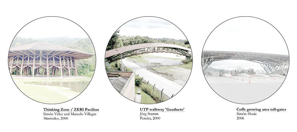
Figure 2: Prominent showcases of constructions with bamboo-guadua.
The Thinking Zone, constructed in Manizales in the year 2000 as a full-scale mock up of the ZERI Pavilion for Hannover 2000, was designed by Simon Velez and Marcelo Villegas. It covers a total surface of 1.650 sqm, with a ten-sided polygon inscribing a 40 m diameter circle, plus 7 m long over hangs all around. It has also a mezzanine of 500 m2 (KRIES et al., 2000).
‘Guaducto’ is a structural bamboo bridge built in 2000 by the German Technical Cooperation Agency (GTZ) and the Technical University of Pereira (UTP) on its campus. It is a 40 m free span elevated walkway designed and constructed by Jörg Stamm (STAMM, 2001).
The toll-gates in the ‘coffee triangle’ designed by the architect Simon Hosie in 2006 was awarded the yearly National Architecture Prize in Colombia. His design combines structural bamboo with steel cables, covering a total area of 600 sqm.
Technological Matrix
Despite the relatively high developement of Colombian industry related to bamboo as building material, particularly as round poles, its state is still underdeveloped compared to its potential and some aspects of the supply chain related to it need to be reconsidered in order to optimize its performance as market product. With the aim of getting a deeper knowledge of all the steps from the forest or the plantation (when bamboo is yet a living being), to the construction site (where if it is used correctly shall last for centuries), the concept of the ‘Technological Matrix’ was introduced.
In the horizontal axis are placed, in correlative order from left to right, the processing steps: 1. Harvest, 2. Cure, 3. Wash, 4. Cut, 5. Bore-hole, 6. Preservation, 7. First drying, 8. Second drying, 9. Remove knots, 10. Split, 11. Flatten, and 12. Lamination. The vertical axis is a technological gradient, with basic technology (hand tools) on the upper part and progressively more complex tools the lower it gets, with heavy machinery in the lower parts of the technological matrix (Figure 3).
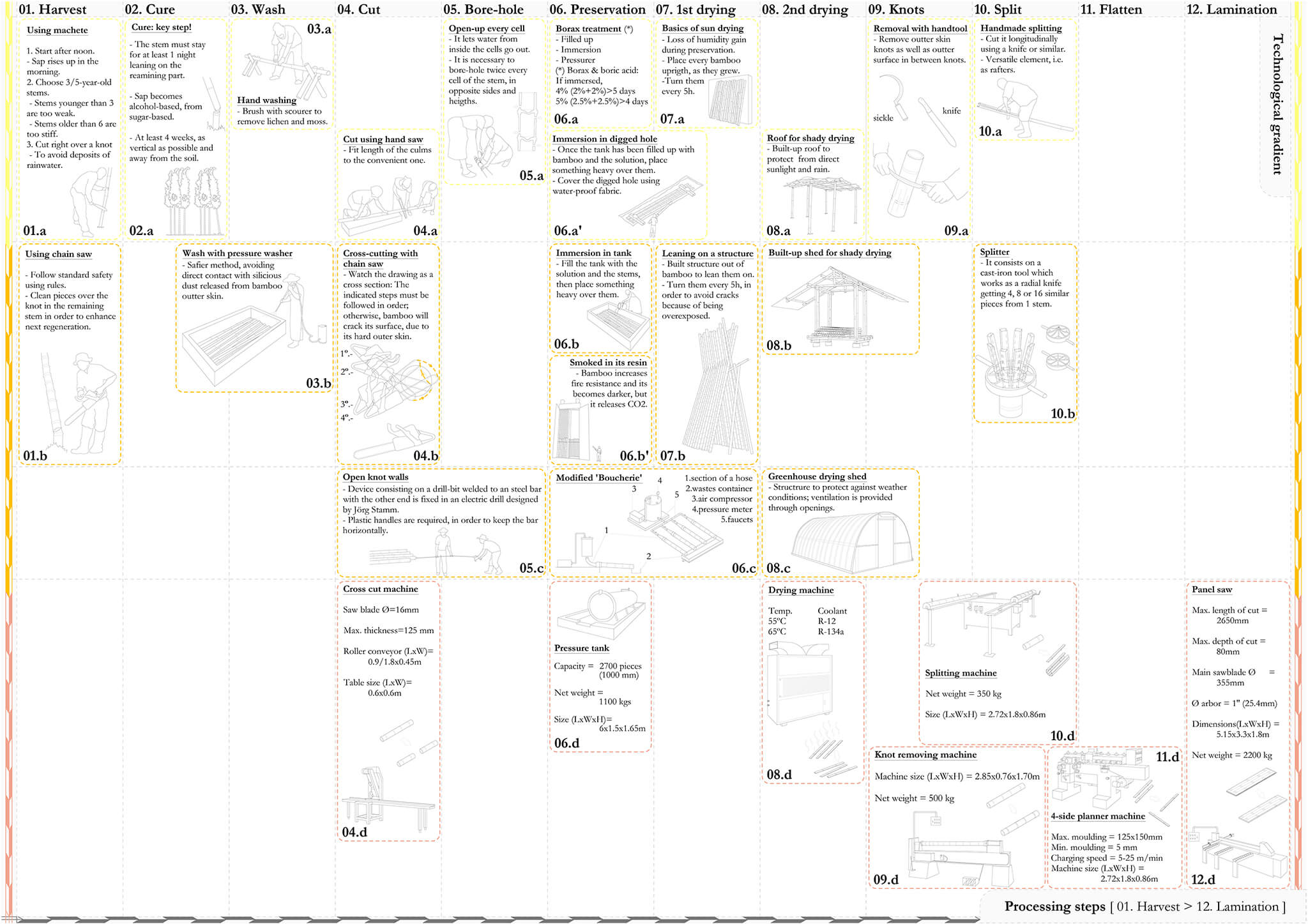
Figure 3: Bamboo Technological Matrix.
The ‘Technological Matrix’ is a tool to help define a particular industry state-of-the-art in a given context, depending on the level of technology available, either as a fact or potential, in order to approach the required investment needed to turn bamboo from raw material to building products (added value chain). Among all the possibilities that the technological matrix shows, the most reasonable one is to follow a diagonal line from top-left to bottom-right, in other words, to use the most basic tools for processing close to the source of raw material and use more sophisticated machinery as the process goes further. In this case, ‘reasonable’ means that the revenues generated by this industry will be more equaly distributed between different social actors and strata, ranging from farmers and small-scale suppliers of the raw material linked to a rural economy, to high-end construction materials producers, more related to urban or suburban settings (Figure 4).
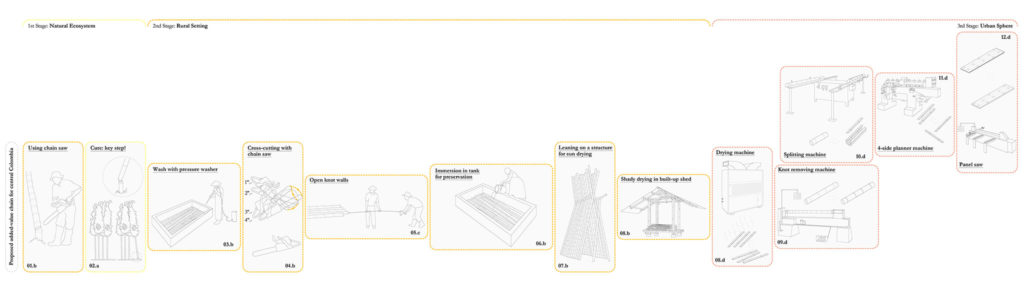
Figure 4: Selected path within the Bamboo Technological Matrix.
Bamboo Construction Market Products
One of the assets of bamboo as building material is its versatility. The first obvious construction product is ‘bamboo round poles’ (natural round poles with a hollow core), as it comes from the grove.
The poles might be split along their long axis, producing irregular laths. But they might also be opened up following that axis and get a fairly flat mat, so the second product would be ‘flatten mats’.
If the irregular laths are profiled and sanded properly, then the third product would be ‘regular laths’. If the flatten mats are glued and pressed together with heat, the fourth product is ‘pressed mat panels’.
The most complex range of products is the laminated products, using regular laths. There are three families of products (the fifth, the sixth and the seventh) depending on how the laths are arranged together: ‘lengthwise laths laminated panels’, ‘crosswise laths laminated panels’ and ‘crosswise laminated beams/columns’ (Figure 5).
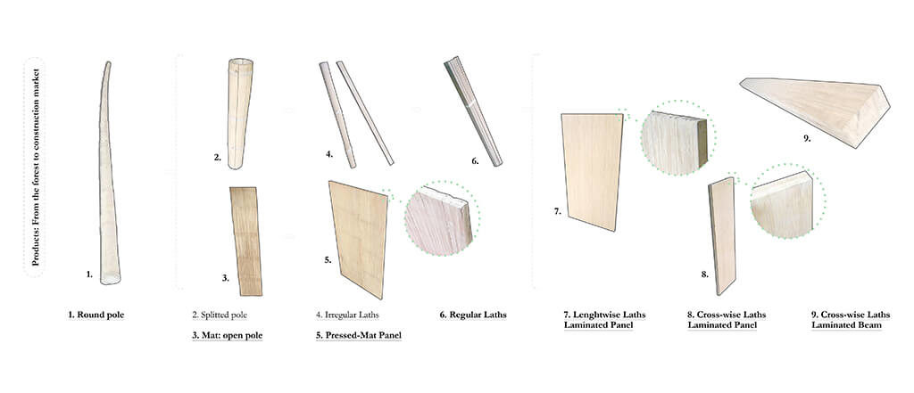
Figure 5: Bamboo based construction market products.
Applying this ‘desired’ diagonal to the Colombian context, the first two steps, ‘1.Harvest’ and ‘2.Cure’, would take place in the rural coffee growing area or the natural ecosystems of those departments, Risaralda, Caldas and Armenia, using basic tools. The next steps, ‘3.Wash’, ‘4.Cut’, ‘5.Bore-hole’, ‘6.Preservation’, ‘7.1st Drying’ and ‘8.2nd Drying’, would take place in rural or semi-urban settings such as the departmental capitals of the coffee growing areas, such as Pereira, Manizales and Armenia, using more advanced tools. The following steps, ‘9.Knots’, ‘10.Split’, ‘11.Flatten’ and ’12.Lamination’, would be carried out in urban or suburban areas, like Bogota, Medellin and Cali, using industrial equipment and machinery (Figure 6).
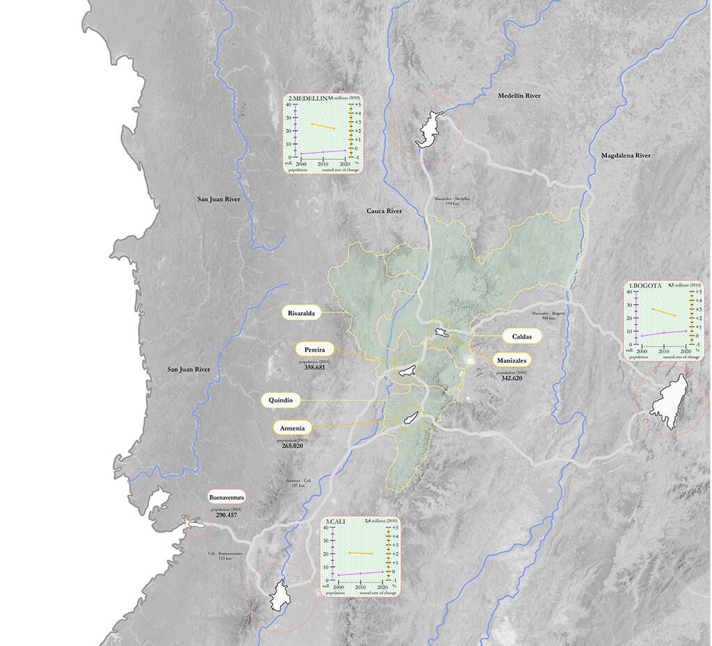
Figure 6: Mapping of the bamboo added-value chain in Colombia.
3. Urban Scale
Medellin: The Most Innovative City
Medellín was known twenty years ago for being one of the most dangerous cities in the world, with one of the highest crime and murders rates. Today, Medellín is the innovation reference for Latin American cities and has been awarded on a number of occasions over the last 6 years, including the ‘Dubai International Award for the Best Practices’ in 2010 for its policy ‘Medellín, la más educada’ addressing the issue of quality education for all; and the ‘Holcim Awards Gold Medal’ by the Holcim Foundation in 2008 to the ‘Integral Urban Project – Comuna 13’ (‘Proyecto Urbano Integral – PUI – Comuna 13’). In addition, in 2013 it was awarded ‘City of the Year’ by the Wall Street Journal and Citigroup for being the most innovative city.
The most distinctive feature of Medellin is its topography located in a valley surrounded by mountains, the so-called ‘tutorial hills’. It was founded in 1616. In 1803 the University of Antioquia was established and the city became the capitol of the Antioquia region in 1826. During the XIX century and beginning of the XX, Medellin became an economic centre for the whole country, not only because of its trade in gold and coffee, but also because of its industries: textile, cigarettes and shoes (Figure 7).
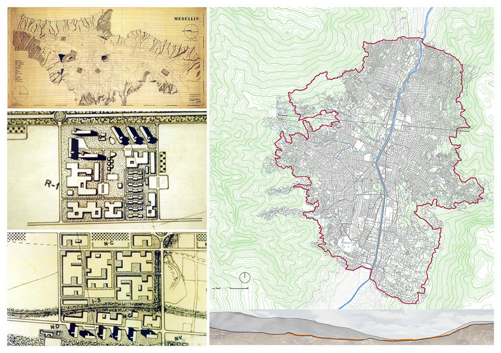
Figure 7: Fragments from the ‘Regulatory Pilot Plan’ for Medellin by Sert and Wiener (Source: .SCHINTTER , 2003). Medellin, plan and section, showing the municipal boundaries and the distinct topography.
After the visits of Le Corbusier, Josep Lluis Sert and Paul Lester Wiener, the ‘Regulatory Pilot Plan’ was formulated and the city planning department was established (MESA et al., 2014). Components of the original plan can be seen today, such as the metro line running along the river side as the main transit system; a sports complex located downtown, which would become the Atanasio Girardot sports centre; an industrial area by the river, which is now ‘El Guayabal’; and an administrative centre, ‘La Alpujarra’.
Social Urbanism
Despite the fight against drug trafficking and organized criminal organizations at local and national levels, Medellin has achieved its transformation through a commitment that involves political will and citizens’ participation. The first mayor to undertake this vast challenge was Sergio Fajardo, in office from 2004 until 2007, who summarized his policies under an umbrella statement: ‘Social Urbanism’. According to the ‘Municipal Development Plan: 2004-2007, Medellin: Commitment of all the Citizens’ (2004), his proposal of ‘Social Urbanism’ was based on the following principles:
1. Human development and quality of life will guide public investment, focusing first on the poorest.
2. Urban projects must integrate simultaneously physical, cultural and social components, improving spaces and interactions of people.
3. Public space projects and infrastructure become the framework meant to be places of gathering and exchange, cultivating education and culture at the same time.
4. The Integrated Metropolitan Transport System is the organizer of mobility axis: all the projects have to be linked to the main transport system.
5. Education and culture are priorities to guide the programs and projects all along the city.
Library Parks Programme
Probably the most acclaimed programme carried out by the municipality of Medellin is the ‘Library Parks’ programme (Parques Biblioteca) due to its radical approach and architectural quality. The idea of the programme is to dignify depressed areas by introducing high-quality public buildings, functioning as libraries with open public green spaces, therefore named ‘Library Parks’.
Even though there are more library parks, either under construction or outside the urban boundaries (i.e. in San Cristobal and in San Antonio de Prado areas) but inside the municipal limits, the focus is on those which are already running within the urban boundaries (MESA, 2014).
Massive Transit Systems in Medellin
Metro
The Metro System of Medellin was opened in 1995. It is an urban train that runs along the riverside from South to North, and from the centre towards West. It has currently 2 lines with 27 stations. It is supported additionally by ‘Aerial Cable Propelled Transit’, being the first massive transit system in the world that combines both means of transport (Figure 8).
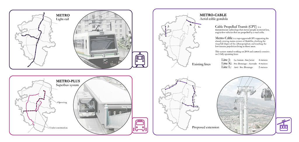
Figure 8: Massive Transit Systems in Medellin.
Metro-Plus
Due to the success of the system in Curitiba, Brazil and Bogota, Colombia, two ‘Bus Rapid Transit’ (BRT) lines were built and currently there is another one under construction, extending the massive transit network.
Metro-Cable
Medellin was the first city in the world to include in its massive transit network a ‘Cable Propelled Transit’, a transportation technology that moves people in motor-less, engine-less vehicles that are propelled by a steel cable. This innovative concept has been adopted by Caracas, Venezuela, and Rio de Janeiro, Brazil. Metro-Cable is a top-supported CPT linked to the already existing metro system of the city, climbing the steep slopes of the urban periphery and reaching the low-income population living in those areas (BRAND and DAVILA, 2011). This system became operational in 2004 and currently there are three fully-operational lines (J, K and L), with a total of nine stations, eight of them within the urban limits of the municipality, serving the daily commuting system.
Transit-Oriented Development
The term TOD, standing for Transit-oriented development, refers to compact, mixed-use, pedestrian-friendly developments that are ‘oriented’ towards massive transit systems and not just adjacent to them. It also serves other community purposes (besides transportation), if linked to a civic square that functions as a community hub (UN-HABITAT, 2013b), playing both a functional and a symbolic role: enhancing the access to public transport, providing mobility choices, increasing safety in public spaces, reducing air pollution and energy consumption, building social capital and increasing commerce and economic activities (CURTIS et al., 2009; CALTHORPE, 1993).
The paradigms are the ‘monocentric’ and the ‘polycentric’ city. The first one has a well defined central business district and a majority of all commuting flows have a radial distribution, from the periphery towards the centre. The latter, on the other hand, has multiple urban centers and produces a mix of radial and lateral trips (UN-HABITAT, 2013b; BERTRAUD, 2001; LEFEVRE, 2009).
To be aware of the influence of a well-developed transit systems network serving an entire city and a car-dependent society, here is a classic comparison (NEWMAN and KENWORTHY, 1999) between two cities: Atlanta and Barcelona, cities with comparable population. In 1990 the population of Atlanta was 2,5 million; 2,8 million in Barcelona. Estimated population in 2013 is 5.25 million for Atlanta and 5,33 million for Barcelona. The urban sprawl characteristic of the North American suburban areas like that found in Atlanta, means that the city covers a surface almost thirty times greater than that of Barcelona. Therefore, massive transit systems in Atlanta were not affordable whereas in Barcelona they were. This fact made the transport related CO2 emissions from Atlanta as much as ten times greater than those in Barcelona (Figure 9).
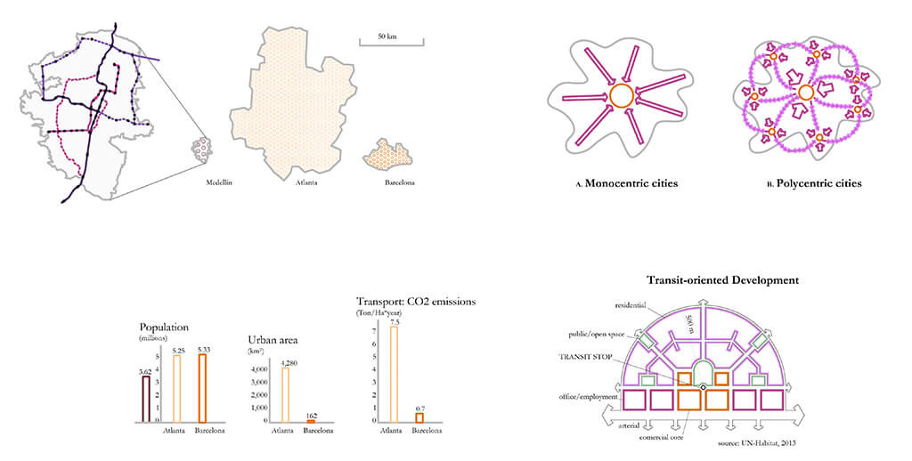
Figure 9: Comparison of population, urban area extension, and trnsport-related CO2 emissions between Atlanta and Barcelona (based on NEWMAN and KENWORTHY, 1999), including also Medellin. Diagram of commuting flows, Monocentric and Polycentric Cities (based on BERTRAUD, 2001; LEFEVRE, 2009). Diagram of how functions are distributed within a Transit-Oriented Development (based on Curtis et al., 2009; Calthorpte, 1993).
Today, almost twenty-five years after this comparison was made, these cities have grown both in population and surface area, but it is a very good example of how massive transport may help save energy, money and space. Although TOD means a paradigm shift in how citizens commute, there is a broader scale to take into account to balance the population and the activities happening citywide. This scale is related to how workplaces and centralities are distributed in the city.
Recent Developments: Case Studies
Housing developments have been designed according to ‘Social Urbanism’ principles with different levels of success in improving quality of life. Here are 2 examples of recent cases, one housing development established on a previously empty plot of land and the other developed as a relocation in-situ.
Las Flores Area – Ciudadela Nuevo Occidente
This project was built in the so-called ‘Expansion Zone’ in the city General Plan (2006). There were 35.000 people living in the area in 2005. It is estimated that in 2014 the population will reach 69.000. Only in Las Flores, 837 identical housing units (47 sqm per unit) were built to house between 2.500 and 3.000 people (Figure 10).
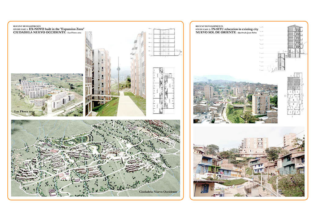
Figure 10: Recent Developments in Medellin, Case Studies.
Quebrada Juan Bobo – PUI Nororiental
PUI stands for ‘Proyecto Urbano Integral’ (‘Integral Urban Project’). It consists of a series of developments within the consolidated city with the aim of not only upgrading the housing conditions of the dwellers but also taking into consideration accessibility and the provision of services. According to the General Plan, there are areas named ‘high risk zones’, where it is banned to build. However, there are currently hundreds of people living within them. Several projects concerning urban redevelopment of these areas have been promoted by the municipality, relocating on site local dwellers. One of the best examples is Quebrada Juan Bobo, part of a bigger project named ‘PUI Nororiental’.
Analysis and Proposal at the City Level
The current conditions on a citywide scale have been analyzed focusing on public transport and on urban re-development with the participation of the municipality. Public transport has been based on what was running before 2004 and what has been built between 2004 and 2013. Re-development projects have been divided as those related to the renewal of the city centre and the previously mentioned ‘Integral Urban Projects’ (PUI) that are already completed.
The proposal at a planning level consists of enhancing the transit network by expanding the aerial cable car system and addressing the ‘High Risk Zones’. The aerial cable car system is extended in a way that turns from a backbone layout, with the river as the main axis and the cable car lines as branches, to a loop shape one connecting the neighborhoods located on the edges of the cities, higher up in the hills surrounding the historic urban centre. The election of the site where the proposal is sampled is leaning towards a new type of public building introduced this year by the municipality, called ‘Articulated Life Unit’ (‘Unidad de Vida Articulada’ – UVA), based on opening up the fences around existing water tanks and renovating them.
The site project, located in the central-eastern part of the city, represents one of the multiple potential sites to adapt the proposal to, this one particularly relevant because it sits nearby one of the lots pointed out as future UVA and also very close to a junction of proposed transit lines (Figure 11).

Figure 11: Analysis and Proposal at the City Level.
4. Local Scale
In 2013 the City of Medellín and UN-HABITAT agreed to join forces to undertake urban redevelopment in an innovative manner, including the poorest and most vulnerable areas.
According to a press release (UN-HABITAT, 2013b), the programme aims to help the city achieve more participation and inclusiveness when redeveloping its neighborhoods through land readjustment, therefore it is named ‘Participatory and Inclusive Land Readjustment’ (PILaR). The goal of the programme is to contribute to global knowledge on how to address the issue of successful land readjustment in developing and middle income countries so that other cities in Colombia and throughout Latin America, Africa and Asia can replicate this pilot programme through South-South cooperation (Figure 12).
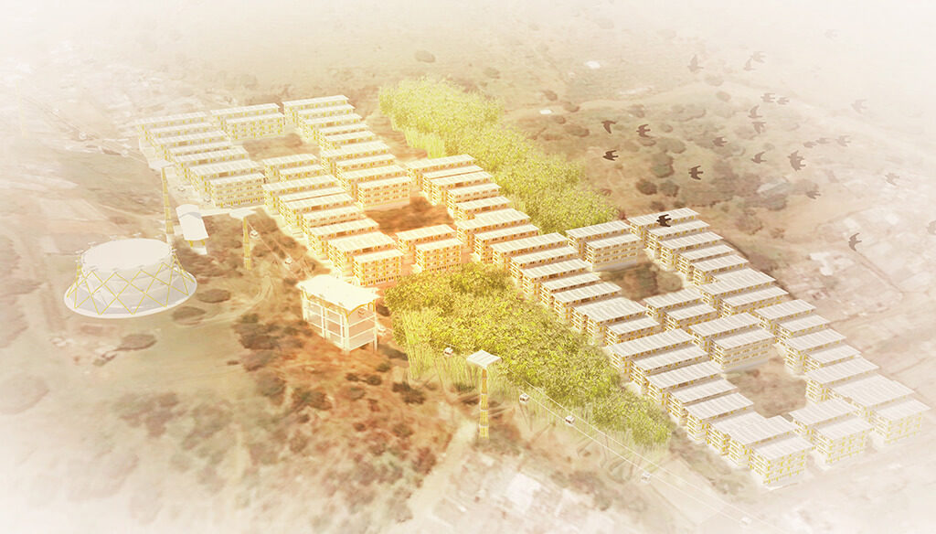
Figure 12: Aerial view of the proposed TOD – PILaR pilot project.
The present proposal endeavors to coordinate the principles of ‘Participatory and Inclusive Land Readjustment’ with those defining ‘Transport Oriented Development’ to support densification of the existing city (Figure 13 and Figure 14).
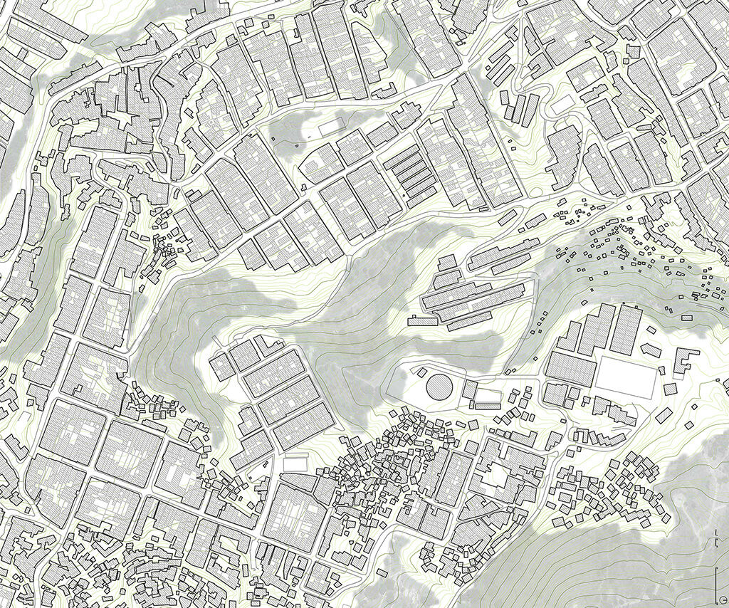
Figure 13: Existing Site Plan.
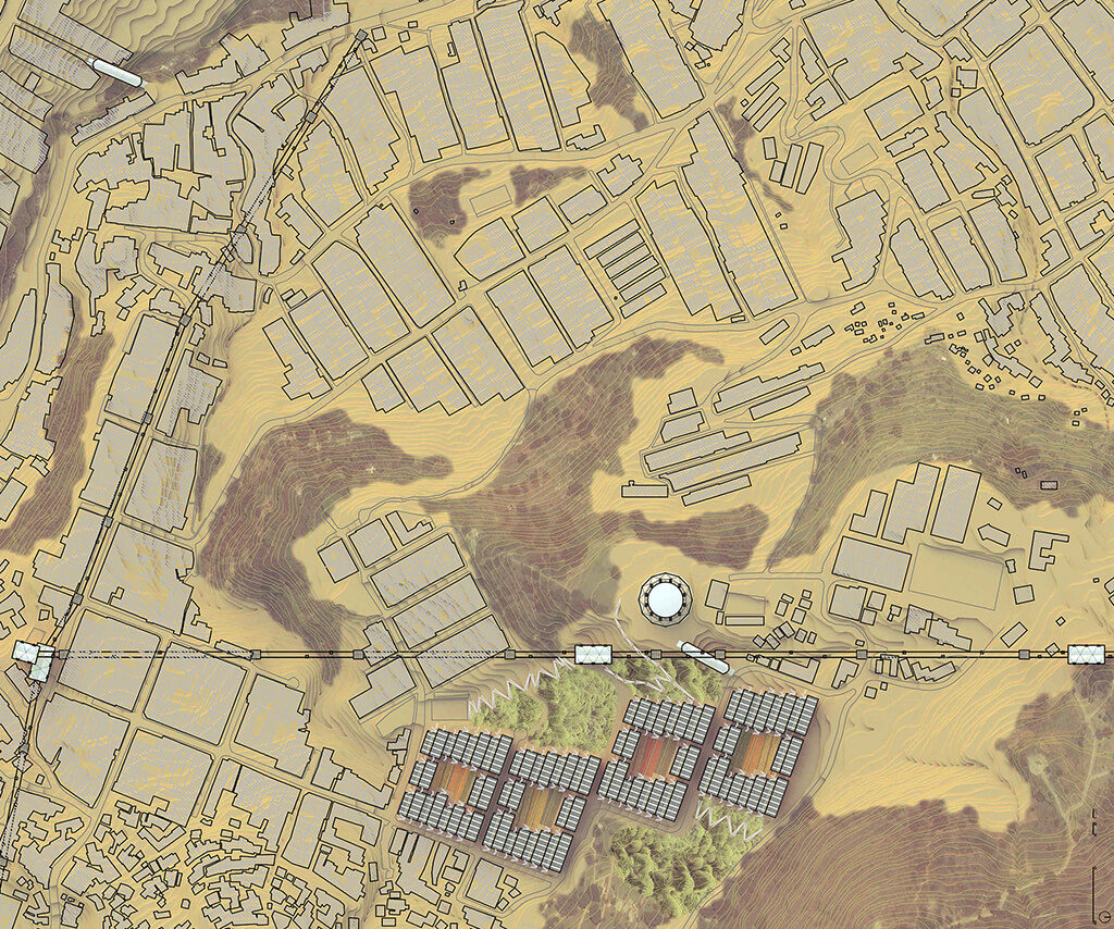
Figure 14: Proposed Site Plan.
The site for the proposed project is located in ‘Villa Hermosa’, an area on the slopes of ‘Pan de Azúcar’, one of the hills surrounding the urban centre. The reason this spot was chosen to benefit from this proposal, among the other potential places in the city, is because of the following key elements (Figure 15).
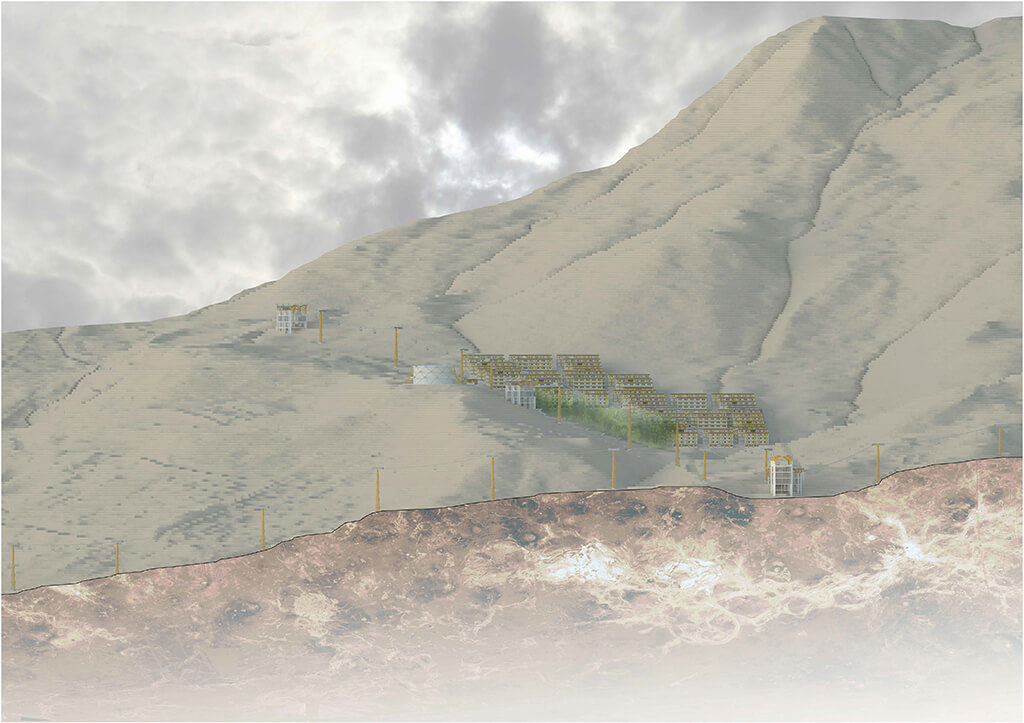
Figure 15: Elevation towards North of the proposed site, showing the nearby peak ‘Pan de Azúcar’.
1. ‘High Risk Area’ defined by the Comprehensive City Plan (2006). Currently around 300 families are living there.
2. ‘Articulated Life Unit’ (UVA) has been proposed in the area as part of the municipal programme consisting of rehabilitating existing water tanks and turning them into community centres.
3. Ravines concentrated in the area due to irregular and steep topography result in disconnected pedestrian networks.
4. Transit stations are proposed in the area to expand the metropolitan transit system using aerial cable-propelled cars, suitable for this kind of hilly landscape.
The design proposal consists of 4 open blocks composed of linear blocks placed along their edges, creating open courtyards which work as community clusters. Each open block has at least one side aligned with the existing streets. These streets are the only ones allowing car traffic. There are 3 sizes of linear block (block 4:5, 25 m; block 5:6, 30 m; and block 6:7, 35 m), all of them designed as double-bank apartments with cross ventilation between the street and a common open corridor running along the middle of the block. Each and every block is placed following the topography which is slightly modified from the current conditions (Figure 16).
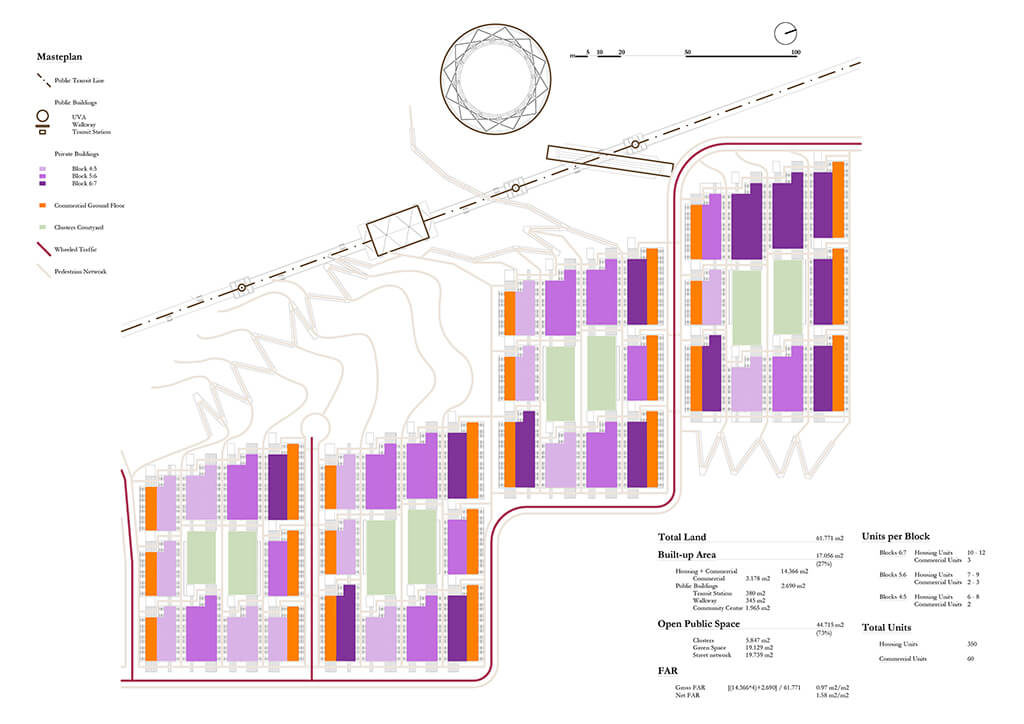
Figure 16: Proposed Masterplan.
Pedestrian circulation occurs across the open block by public stairs running up the slope and by alleyways between every two consecutive linear blocks in the same cluster. These alleyways, although designed only for pedestrians, allow eventual circulation of fire engines in case of emergency.
A series of ramps climbing up the ravine complement the pedestrian network and make the area accessible for the handicapped. In between these ramps are wetland terraces working as on-site wastewater treatment plant at the same time as providing recreational and educational public spaces. It is also the link between the residential and commercial area with the public transit system and the community centre or ‘Articulated Life Unit’ (UVA). In the steepest part of the ravine a pedestrian walkway over the wetland connects the two areas, establishing a dialogue between the open space enclosed in clusters and the open space related to the public realm, combining circulation and green spaces with public buildings and infrastructure.
Water Cycle System within the Development
Regarding water, a ‘closed cycle’ is proposed, which differs from regular urban water networks which are based on a linear system with different levels of centralization and infrastructural facilities in both ends of the system, while the closed water cycle proposed collects, uses, re-uses and recycles the water in situ (TANNERFELD and LJUNG, 2006). System performance is based on separate pipelines: storm water, used water and clean water (Figure 17).
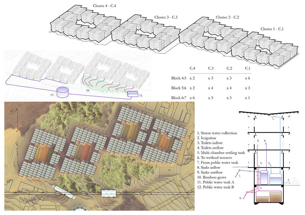
Figure 17: Water Cycle System within the development.
Storm water
It is collected from the roofs and stored in underground tanks located in the basement of every block. It is directly used for the gardens located in the courtyards and for flushing toilets.
Used water
Flushed water from toilets first goes through a separator which separates water from the sewage. The water flows through the bamboo grove, and what remains stays in a multi-chamber settling tank until it becomes aseptic and can be used as bio-mass.
Clean water
Water from sinks and that which is extracted from the sewage system is cleaned by passing through a multi-level constructed wetland in terraces (bamboo grove) for treatment before reusing it.
As a pilot project, the aim is to show how these different components can be applied in similar conditions in other parts of the city, as well as other cities, not only in the region but also on other continents. Therefore, the proposal is at the same time generic, because most of it could be translated elsewhere, and specific, since social and climatic conditions of the site are dealt with in the present project.
There are 4 urban components structuring the proposal, 2 of them regarding mobility and the other 2 regarding shelter, both for the community and private dwelling (Figure 18):
a. Walkways
b. Cable Propelled System (MetroCable)
c. Community Centre (UVA)
d. Social Housing
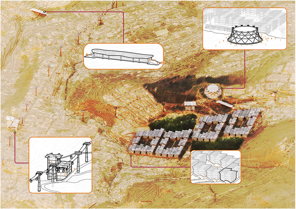
Figure 18: Axonometric view of the proposed site for the pilot project in ‘Villa Hermosa’ – Comuna 8, showing the urban components.
Next, each of the previously mentioned urban components is described in detail, mainly from a constructive perspective. As seen before, these components represent the key aspects of the proposal: Mobility, Community and Housing.
Mobility
Mobility is a crucial component in how cities perform. Pedestrian traffic and massive transit systems are the most suitable and sustainable means of moving around (the topography of Medellin makes it less cyclist friendly). Walkways and the infrastructure required for extending the cable-propelled system are the urban components designed targeting mobility (Figure 19).
Community
The anchor for the site from the social perspective is the existence of a water tank, selected by the municipality as an ‘Articulated Life Unit’, which shall function as a community centre named ‘Sol de Oriente’.
Housing
In order to assure proper land management, building works and maintenance of the public space, the housing system proposed should be described as social due to the involvement of the municipality.
Mobility/Urban Component 1: Pedestrian Walkways
Pedestrian walkways structurally based on bamboo arches of 40 meters free span are located in special spots linking ravines’ 2 sides, which are very common in the so called ‘High Risk Areas’, enhancing the pedestrian traffic network.
The design allows for prefabrication on site; assembling all the constructive elements; composing the whole structure right next to the place where the bridge is going to be located; lifting it up and placing it on site.
Trusses are composed of upper and lower arches made out of bamboo bundles, leaning on each other and connected by reinforcement rings made of beam-column systems which might be used also for independent roof structures.
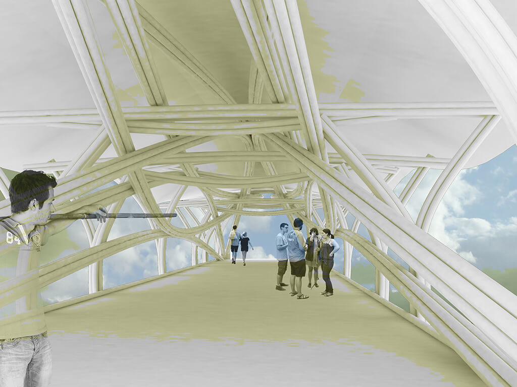
Figure 19: Bamboo walkway.
Mobility/Urban Component 2a: Aerial-Cable Car Stations
New stations, part of the extension of the aerial cable propelled system, are designed with a bamboo based roof structure. This structure is based on the so called ‘fish belly truss’ standing on a V shaped support which sits on reinforced concrete columns. Steel wires complete the structural system of this basic module.
A section of the roof structure is made when 4 of these modules are placed together. The basic structural module could also be used independently, for instance, to roof the stands of open-air sports fields.
Mobility/Urban Component 2b: Aerial-Cable Car Columns
Columns supporting the cables for the proposed extension of the system are also based on load-bearing bamboo. These columns are configured by stacking modules on top of each other, reducing their cross section as they are placed in higher positions.
Each one of these modules is based on Vladimir Shukov’s towers, consisting of hyperboloids of revolution or circular hyperboloids, which is a doubly ruled surface where the rules are bamboo stalks.
There are 2 groups of these rules with both ends of each resting in a steel ring, with a vertical element (a 7-bamboo bundle) in the core of each module.
Community/Urban Component 3: Articulated Life Unit UVA
As part of the programme named ‘Articulated Life Unit’ (UVA stands for the initials in Spanish, ‘Unidad de Vida Articulada’), the existing water tank in the area will be renovated and named ‘UVA Sol de Oriente’.
The water tank is incorporated into the project since it is an asset to the community. The water tank is extended from 5 to 15 meters in height and an outer structural skin, also in hyperboloid like shape, is constructed out of bamboo bundles to reinforce the needed structural demands and at the same time provide room to accommodate the functions of a community centre.
Housing/Urban Component 4: Social Housing System
The status of ‘social’ for the proposed housing system refers to the role played by the municipality in managing the land, in the building works and in the maintenance of the area. The proposed model is based on the municipality covering expenses related to urbanization, including the construction of wetland terraces for grey water treatment and the structures as well as both electrical and sanitary systems for housing, whereas the dwellers are responsible for partitions and finishing within their own units and the maintenance of the common spaces, such as courtyards and alleyways in the housing clusters (Figure 20).
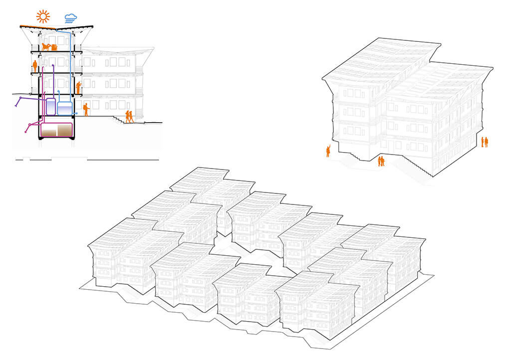
Figure 20: Bamboo based construction system for Social Housing.
The building type for this housing is a linear block which is a double-bank corridor housing composed of 2 bodies, one a module longer than the other, and with a stepped profile to fit the topography, slightly modified from existing conditions (Figure 21).
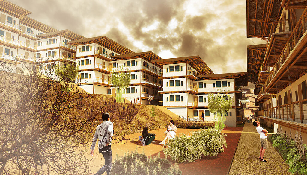
Figure 21: Visualization of one of the Housing Clusters.
5. Detail Scale
Open Spaces Typology
The open spaces network is composed of four types of open spaces: 1. Bamboo groves, 2. Courtyards, 3. Commercial streets, and 4. Alleyways. These four components structure the entire urban development proposal and provide a clear distinction between wheeled and pedestrian traffic, with the latter prevailing. Not only is the mobility issue solved, but also the community and individual needs of outdoor spaces are fulfilled, including recreational spaces, commercial areas, playgrounds, recycling facilities and urban farming (Figure 22).
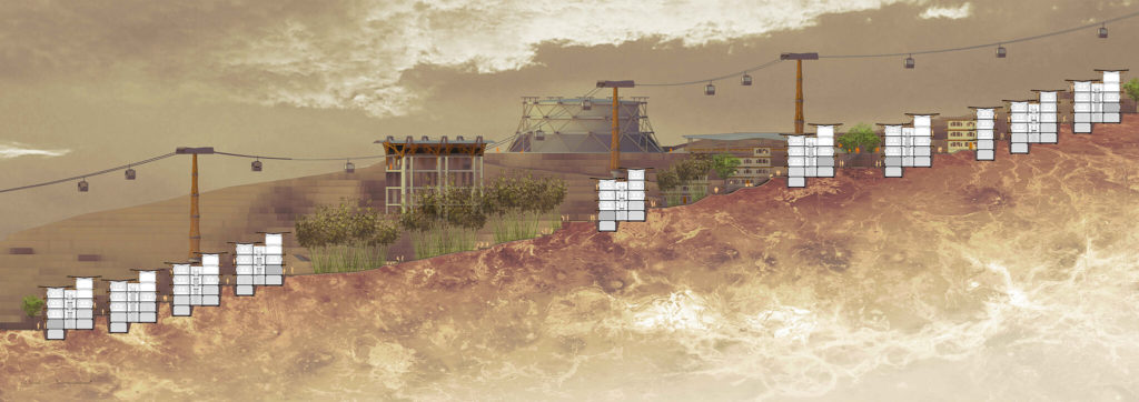
Figure 22: Urban section through the main open spaces in the proposal.
Open Spaces Typology 1: Bamboo Groves
The key component of the open spaces network is the bamboo groves. Located next to every housing cluster, they have a triple function: A. Recreational: Bamboo groves are meant to be a place for inspiration, relaxation and gathering for the community dwellers and visitors; B. Infrastructural: Swales located throughout the bamboo groves will purify the water coming from the septic tanks; and C. Economic: It works as a productive source of raw material for further developments and different uses (Figure 23 and Figure 24).
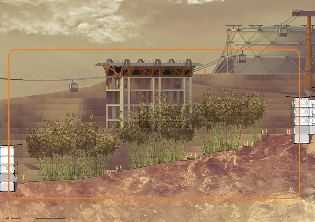
Figure 23: Detail urban section of one of the bamboo groves.
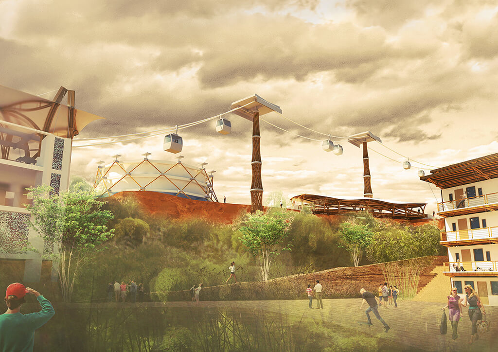
Figure 24: Visualization of one of the Bamboo Groves.
Open Spaces Typology 2: Clusters Courtyard
In the core of every housing cluster there is a courtyard to be managed by the dwellers of that cluster for urban farming, recycling facilities and playgrounds (Figure 25 and Figure 26).
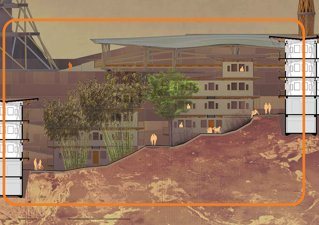
Figure 25: Detail urban section of one of the Clusters Courtyard.
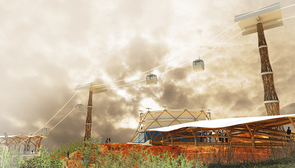
Figure 26: Visualization of the main public area, where a walkway meets a public transit stop.
Open Spaces Typology 3: Commercial Street
Between every two housing clusters there is commercial street with shops and services located on the ground floor of the buildings framing it. There are two lanes for wheeled traffic in the middle of the street, room for parking on both sides and trees creating a canopy over the sidewalks (Figure 27).

Figure 27: Detail urban section of one of the Commercial Streets.
Open Spaces Typology 4: Clusters Alleyways
Linking the outer side of the housing clusters with their inner courtyard, there are a series of alleyways between the linear blocks that compose the cluster. These alleyways are more intimate spaces than the commercial streets and for pedestrian use only, although they are wide enough to allow emergency vehicles, such as ambulances and fire engines. There are swales running right next to the buildings to direct the water from the septic tanks to the bamboo groves (Figure 28).

Figure 28: Detail urban section of one of the Clusters Alleyways.
Detail Plan
The detail plan shows all the elements of the proposal, both urban components for mobility (pedestrian walkways and aerial cable cars massive transit system), community (housing clusters and community centre or ‘Articulated Life Unit’) and housing (linear blocks of social housing), and four categories of open spaces (bamboo groves, cluster’s courtyards, commercial streets and alleyways). Also shown is how all these elements are related and how they work together creating an urban environment which enhances public life, at the same time providing different levels of privacy (Figure 29).
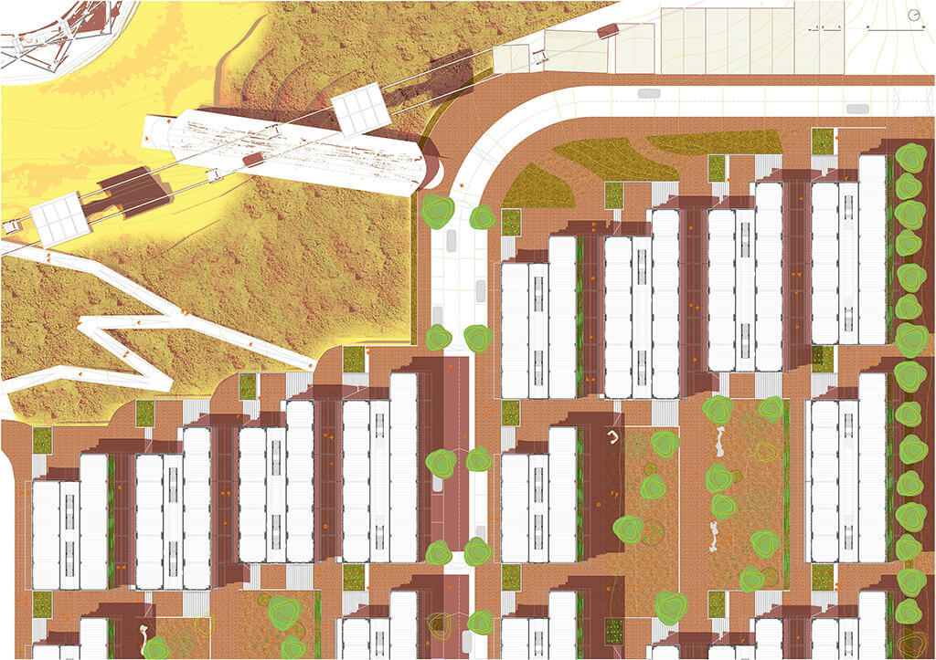
Figure 29: Detail plan of the proposed pilot project.
Housing Construction System
This building type, 3 storeys (9 meters tall) made out of bamboo, is based on one single kind of truss. Four classes of minor components assembled together generate one truss. These components are: columns (2 per truss), floor beams (2 per truss), roof beams (1 per truss) and shear reinforcement (6 per truss). Therefore, with a total amount of 11 components (belonging to 4 different classes) designed to be prefabricated in a workshop, shipped to the site and assembled at the construction site, a 3-storey prefabricated in-situ truss is built, just before being lifted up and placed in its right position.
The previously described trusses are combined in pairs. Two in a pair are connected through a shared corridor which also hosts the staircases. Trusses of a pair are placed at different heights due to the topography, leading to the characteristic stepped profile.
Floor beams and shear reinforcements are also placed at every level in between 2 consecutive trusses in parallel, achieving a structural module for the linear blocks with approximate dimensions of 5 by 5 meters horizontally and 9 meters in height. The size of the linear blocks ranges from 4 to 7 modules (20 to 35 meters per block), one after the other.
All the structural elements made out of bamboo are already in place, on top of a reinforced concrete structure which works as foundation and basement. A compression layer in every floor poured over a bamboo grid is the other major part of the construction using concrete. Partitions and exterior walls consist of double bamboo mats, both plastered on their outer surface, and attached to a light frame also made out of bamboo. On the roof, solar devices are installed, such as solar water heaters and photovoltaic panels to generate electricity.
Housing Units
There are four different housing units proposed within the frame of the linear blocks. These units fit in the grid set up by the structural system previously described, occupying either 2 or 3 modules in the horizontal plane. Each module has a surface of 24 sqm. Two of these units are single-storey and two are double-storey.
Every housing unit is accessed from the corridor running between the 2 bodies of each linear block and has at least one balcony towards the street. The interior surface of the housing units ranges from 48 to 144 sqm, with the aim of satisfying various housing demands. Those units which are double-storey are designed to make possible a second level which can be added later, as economic resources of the dwellers allow (Figure 30).
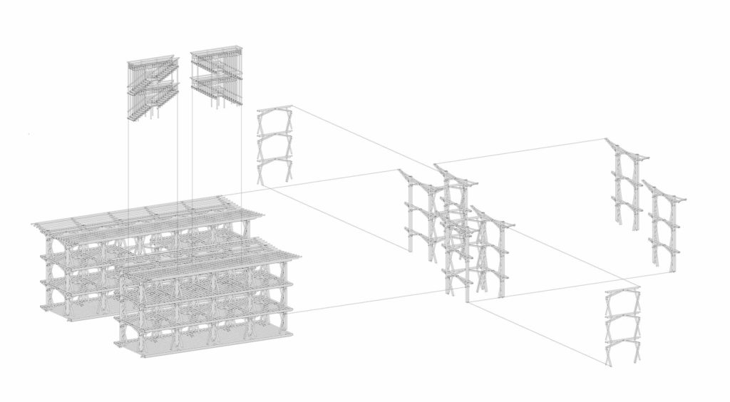
Figure 30: Components of the bamboo based construction system for Social Housing.
Conclusions
Bamboo has proven its importance in making more sustainable cities from an environmental, social and economic point of view. It is relevant today, being not only extremely renewable, but also widely available in those areas where urban population is growing at the fastest rate, and it will be even more relevant in the future.
The places where bamboo is available as a local resource and where the population, especially urban, is growing fastest, are primarily developing economies. This allows for the development of an economically viable industry that spreads the benefits of processing bamboo to obtain added-value products.
Colombia is the country where research, industrial development and construction have gone the furthest to date. In that particular context, proof has been provided on how proper management of the resource makes bamboo a reliable, high-quality, long-lasting building material.
The city of Medellin was chosen for the design proposal due to all the accomplishments achieved in the last decade regarding urban innovation, participatory design and pro-low-income policy making. ‘Transport Oriented Developments’ (TOD) towards a polycentric organizational scheme of the city and ‘Participatory and Inclusive Land Readjustments’ (PILaR) are the foundations for the design proposal. Villa Hermosa, located on the foothills of Pan de Azucar, is selected as the site for the pilot project as reference for various potential locations where the design proposal may take place within Medellin.
The design proposal, consisting of a TOD-PILaR redevelopment plan for targeted areas within the city, is structured by urban components addressing mobility, community and housing. The mobility network proposed is pedestrian oriented with the support of a public massive transit system. Pedestrian traffic is enhanced by elevated walkways over ravines, built with structural bamboo. The roofs of the stations as well as the columns supporting the cable propelled transit system are also built using structural bamboo. Community development is promoted by the construction of an ‘Articulated Life Unit’, a community centre placed on an existing water tank, also designed with structural bamboo, and a social housing system of linear blocks creating open clusters.
A typology for open public spaces is defined, providing hierarchy and order to the space in between the buildings, including the following categories: bamboo groves with recreational, infrastructural and economic objectives; courtyards enclosed by the housing blocks of the same cluster, commercial streets between different clusters; and alleyways connecting the clusters courtyard with the rest of the urban network. The proposed social housing is a modular system based on a truss with a high level of prefabrication which requires a low level of skill. It is designed in such a way that the housing units in the linear blocks are incremental within the structural framework.
References
ANDERSSON, L., ARNSBY, L., JOHANSSON, B., PERING, C. and ÅSTRAND, J. 1986. ‘A SOLUTION TO RURAL HOUSING PROBLEMS. EXPERIENCE FROM A PILOT PROJECT IN TUNISIA BASED ON DO-IT-YOURSELF BUILDING’. Swedish Association for Development of Low-Cost Housing (SADEL). ISBN 91-86596-08-X.
BERTRAUD, Alain, 2001. ‘METROPOLIS: A MEASURE OF THE SPATIAL ORGANIZATION OF 7 LARGE CITIES’, http://alain-bertraud.com, last accessed 2 April 2014.
BLANCO, Carolina, KOBAYASHI, Hidetsugu, 2009. ‘URBAN TRANSFORMATION IN SLUM DISTRICTS THROUGH PUBLIC SPACE GENERATION AND CABLE TRANSPORTATION AT NORTHEASTERN AREA: MEDELLIN, COLOMBIA’. The Journal of International Social Research. Ordu, Turkey.
BRAND, Peter, DAVILA, Julio, 2011. ‘AERIAL CABLE-CAR SYSTEMS FOR PUBLIC TRANSPORT IN LOW-INCOME URBAN AREAS: LESSONS FROM MEDELLIN, COLOMBIA’, paper presented at the 3rd World Planning Schools Congress, Perth (WA), 4-8 July 2011.
CALTHORPE, P., 1993. ‘THE NEW AMERICAN METROPOLIS: ECOLOGY, COMMUNITY, AND THE AMERICAN DREAM’, Princeton Architectural Press. New York, USA.
CURTIS, C., RENNE, J., BERTOLINI, L., 2009. ‘TRANSIT ORIENTED DEVELOPMENT: MAKING IT HAPPEN’, Ashgate. Surrey, UK.
DAVIS, Mike, 2006. ‘PLANET OF SLUMS’, Verso Books. London, UK.
DUNKELBERG, Klaus, 1985. ‘BAMBOO AS A BUILDING MATERIA. IL31 – BAMBOO’. Institute for Lightweight Structures (Ed.), University of Stuttgart. Stuttgart, Germany.
LE CORBUSIER (Charles-Edouard Jeanneret), 1923. ‘VERSE UNE ARCHITECTURE’. ISBN 0-89236-822-5.
LEFEVRE, Benoit, 2009. ‘URBAN TRANSPORT ENERGY CONSUMPTION: DETERMINANTS AND STRATEGIES FOR ITS REDUCTION’. S.A.P.I.E.N.S. (Online), 2.3 / 2009. Online since 15 December 2009. URL: http://sapiens.revues.org/914, last accessed on 5 May 2014.
LERNER, Jaime, 2005. ‘ACUPUNTURA URBANA’. IAAC – Institut d’Arquitectura Avançada de Catalunya. Barcelona, Spain.
HIDALGO-LÓPEZ, Oscar, 2003. ‘BAMBOO: THE GIFT OF THE GODS’. Oscar Hidalgo-López Ed. Bogota, Colombia.
KRIES, Mateo, VON VEGESACK, Alexander, 2000. ‘GROW YOUR OWN HOUSE’. Vitra Design Museum, Weil am Rheim, Germany.
McCLURE, F. A., 1953. ‘BAMBOO AS A BUILDING MATERIAL’ US Department of Agriculture – Foreign Agriculture Service. Washington DC, USA.
McDONOUGH, William, BRAUNGART, Michael, 2002. ‘CRADLE TO CRADLE: REMAKING THE WAY WE MAKE THINGS’. North Point Press. New York. ISBN 0 86547 587 3.
MEDELLIN MUNICIPALITY, 2004. ‘PLAN DE DESARROLLO MUNICIPAL 2004-2007, MEDELLIN: COMPROMISO CON TODA LA CIUDADANIA’. Alcaldía de Medellín, Medellín, Colombia.
MESA, Carlos, MESA, Miguel, TOLEDO, Rodrigo, 2014. ‘GUÍA DE ARCHITECTURA DE MEDELLÍN’. Mesa Editores. Medellín, Colombia.
MINKE, Gernot, 2012. ‘BUILDING WITH BAMBOO’. Walter De Gruyter Incorporated.
NEWMAN, P., KENWORTHY, J., 1999. ‘CITIES AND AUTOMOBILE DEPENDENCE: AN INTERNATIONAL SOURCE BOOK’. Gower, Aldershot, UK.
PAULI, Gunter, 2010. ‘THE BLUE ECONOMY. 10 YEARS, 100 INNOVATIONS, 1000 MILLION JOBS’. Report to the Club of Rome. Paradigm Publications. ISBN 97809122111902.
PAYNE, Geoffrey, 2003. ‘REGULATORY GUIDELINES FOR AFFORDABLE SHELTER’, Paper presented at International Workshop on Regulatory Guidelines for urban Upgrading (RGUU), arranged by the Intermediate Technology Development Group (ITDG).
PEÑALOSA, Enrique, 2007. ‘POLITICS, POWER, CITIES’, in ‘THE ENDLESS CITY’. Phaidon Press.
RODRÍGUEZ, Carlos Mario, 2009. ‘LA TRANSFORMACIÓN DE MEDELLÍN, UNA ACCIÓN SOLIDARIA’. Alcaldía de Medellín. Medellín, Colombia.
RIST, Gilbert, 1996. ‘LE DÈVELOPMENT – HISTORIE D’UNE CROYANCE OCCIDENTALE’, Presses de la Fondation Nationale des Sciences Politeques, Paris, France.
SATTERHWAITE, David, 2005. ‘THE SCALE OF URBAN CHANGE WORLDWIDE 1950-2000 AND ITS UNDERPINNINGS’. International Institute for Environment and Development, IIED. London, UK.
SCHNITTER, Patricia, 2003. ‘SERT AND WIENER IN COLOMBIA. THE SOCIAL DWELLING IN THE APPLICATIONS OF MODERN URBANISM’. Universidad de Barcelona, Scripta Nova. ISSN: 1138-9788.
SCHUMACHER, Ernst Fritz, 1973. ‘SMALL IS BEAUTIFUL: A STUDY OF ECONOMICS AS IF PEOPLE MATTERED ’. Blond & Briggs.
SODERSTOM, T. R., ZULOAGA, F. O., 1989. ‘A REVISION OF THE GENUS OLYRA AND THE NEW SEGREGATE GENUS PARODIOLYRA (Poaceae, Bambusoideae, Olyreae)’. Smithsonian Ed., Washington DC, USA.
STAMM, Jörg, 2001. ‘Guía para la Construcción de Puentes en Guadua. Proyecto UTP-GTZ’. JM Calle Editorial. Pereira, Colombia.
STULZ, Roland, MUKERJI, Kiran, 1993. ‘APPROPIATE BUILDING MATERIALS’. SKAT. ISBN 3 908001 44 7.
TANNERFELDT, Goran, LJUNG, Per, 2006. ‘MORE URBAN, LESS POOR: AN INTRODUCTION TO URBAN DEVELOPMENT AND MANAGEMENT’. Earthscan. London, UK.
TURNER, John F. C., 1977. ‘HOUSING BY PEOPLE: TOWARDS AUTONOMY IN BUILDING ENVIRONMENTS’. Pantheon Books.
UN-HABITAT, 2013a. Press Release ‘The City of Medellín and UN-HABITAT join efforts to innovate in urban redevelopment’. 18 April 2013, Nairobi, Kenya.
UN-HABITAT, 2013b. ‘Planning and Design for Sustainable Urban Mobility. Global Report on Human Settlements 2013’. United Nations Human Settlements Programme. Routledge, New York, NY – USA.
UN-HABITAT, 2013c. ‘53 UN-Habitat Model Projects 2013/2014’, Nairobi, Kenya.
UN-HABITAT, 2013. ‘STREETS AS PUBLIC SPACES AND DRIVERS OF URBAN PROSPERITY’, Nairobi, Kenya.
UNITED NATIONS, 2013. The Department of Economic and Social Affairs – Population Division (UN-DESA), ‘WORLD POPULATION PROSPECTS. THE 2012 REVISION. HIGHLIGHTS AND ADVANCE TABLES’. Working Paper No. ESA/P/WP.228. New York, NY – USA.
VENTURI, Robert, 1966. ‘COMPLEXITY AND CONTRADICTION IN ARCHITECTURE’. The Museum of Modern Art Press. New York. ISBN 0-87070-281-5.
Download PDF file from the ‘World Bamboo Organization’ website (34,8MB)
–
All rights reserved.
© J. E. Espinosa Benito, 2.026